-
January 18, 2026RAPTORSupport decision-making for terrestrial traffability: Phase 1: Research and development of a demonstrator.
Geo212 has been awarded the RAPTOR research and development contract by the DGA.
Geo212 is leading an industrial consortium comprising Magellium, BRGM and CAR&D on a project divided into three phases (one fixed and two optional, lasting approximately 36 months). The main outcome will be the development of a trafficability demonstrator for the armed forces at strategic, operational and tactical levels.
Follow us on LinkedIn for updates on this project!

-
11 March 8, 2026Training "Introduction to Geospatial Analysis"in partnership with FERDI and IHEDD for the Borders Academy
We delivered this training remotely, in interactive sessions.
It focused on mapping and spatial analysis using QGIS software.
The session brought together 40 trainees (police officers, gendarmes, customs officers, forestry workers, and military personnel) from 11 African countries.
The program is based on a demanding methodology aimed at acquiring certified skills :
-🎓 Intensive QGIS training.
-🗺️ Exploration of geographic data, satellite imagery, etc.
-🛠 Practical GeoIntelligence application exercises.
-💻 Interactive virtual classrooms, continuous monitoring, and individual assessment.
The objective: to combine academic rigor with the power of digital technology to transform geographic data into a decision-making tool in the field.
A huge thank you to the Borders Academy and the Directorate of Security and Defense Cooperation of France 🇫🇷 for their continued trust and support of this large-scale project 🤝

-
March 2, 2026University teachingGeoint at the Catholic University of Lille
The arrival of spring coincides with the end of the "Introduction to GeoInt" module designed by Geo212.
Students will have alternated between theoretical content (GeoInt, geolocated data, GIS, etc.) and practical work on QGIS (data integration, spatial analysis, cartography, etc.), with their project as the common thread. During these 24 hours of teaching, they will have discovered the rich ecosystem of geolocated data and satellite imagery, as well as a wide range of QGIS functions.
The final project enabled them to apply their theoretical knowledge to real-life use cases and analyses.
The exchanges were rich and the overall quality of the projects confirms that the discipline has its place in this course. -
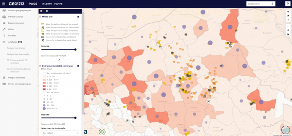
October 12, 2023WebinairePOGS presentation at the mviewer webinaire
During the mviewer webinar, Geo212 presented the POGS (Prototype Of the Observatory for Gold and Security) web-GIS platform: a prototype observatory of gold-panning practices in the Liptako Gourma and their impact on security.
During the mviewer webinar, Geo212 presented the POGS (Prototype Of the Observatory for Gold and Security) web-GIS platform: a prototype observatory of gold-panning practices in the Liptako Gourma and their impact on security.
This project, funded by the European Space Agency (ESA) for the Liptako Gourma Authority, was developed by Geo212, accompanied by Pixstart and Anthropolinks.
It is part of the Extractive Industries Transparency Initiative (EITI) supported by the OECD, which aims to identify the risks associated with the gold supply chain.
Translated with www.DeepL.com/Translator (free version)
-
September 14,2023ConferencePresentation of 14kg at GeoDataDays
Geo212 and Murmuration presented their new Web-GIS platform at GeoDataDays 2023 in Reims!
Geo212 and Murmuration presented their new Web-GIS platform at GeoDataDays 2023 in Reims!
This platform brings together a wide range of data (population density, pollution, agriculture rates, technological risks, etc.) and provides an environmental quality indicator for each Ile-de-France town.
-
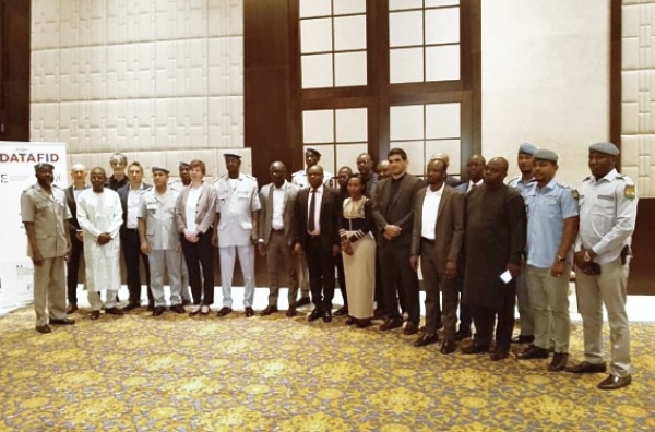
April 5, 2023DATAFID workshop facilitationGEOINT for customs, Event
Geo212 attended the DATAFID workshop in Niamey to get feedback on the GEOINT e-learning training designed for customs.
-
March 9, 2022ContractGeo212 wins ESA call for projects
Geo212 won the European Space Agency (ESA) call for projects to develop an Earth observation service to support the Integrated Authority of Liptako Gourma (ALG) in its participation in the West African capacity building program on gold mining practices, under the auspices of the OECD.
-
July 8, 2021WebinarCNES and Aerospace Valley Copernicus Challenges Webinar
Pixstart, in partnership with Geo212, won the Communities Challenge award proposed by CURAT for the project: Mapping gold mining sites in Ivory Coast. The restitution of the winners' work took place on May 18, 2021 during the “Copernicus Challengers on stage” webinar.
The Copernicus Challenges was launched in 2020 by CNES / Connect by CNES and Aerospace Valley, a "Copernicus Challengers on stage" webinar was held on May 18 to present the winners. The objective of the challenges was to bring out innovative and operational solutions integrating Copernicus data.
The awardees had six months to develop a pilot with support from CNES experts.
Pixstart, in partnership with Geo212, won the Collectivities Challenge proposed by CURAT for the project: Mapping gold mining sites in Ivory Coast. Discover CURAT projectPixstart and Geo212 proposed a hybrid approach combining the use of Sentinel data with AI, and complementary geospatial data, to result in qualified gold mining site detections.
To watch the recording of the webinar, click here
-
November 7, 2022Welcome to Alice Flon !Recruitment
Alice Flon joins the team as a geographic analyst, welcome to Geo212 !

-
July 2021PublicationSatCen Hovering Horizon
The new issue of Hovering Horizon 2021 is released. It contains a reader’s digest of the most relevant advances and recent events in the field of Earth Observation that concern the realm of Security, analyzed by SpaceApplication and Geo212 experts.
The bimonthly periodical to be in the state of the art in the world of Space and Security. Hovering Horizon is a magazine created by the Copernicus SEA Service. It airs once every two months, and it contains a reader’s digest of the most recent and relevant events in the overlap between the worlds of Space science and Security issues. Within this publication you will find the following topics: R&D and Academia ; Policy and Regulations; Satellite Financing; Upstream Activities ; New Technology / Equipment; Downstream activity / services, and the news about satellite launches and conferences.
Subscribe to the free newsletter.